
Wild Wild Rivers
Host: Hodgson River Station
Written by: Jo Bloomfield – Owner, Hodgson River Station.
I feel a bit odd writing about our over abundance of rain during the wet when I know so many others are currently in drought. Prior to this property my husband and I had operated a property that bordered the Simpson Desert, NT. We had a 6” average rainfall there and if we had actually got that rain each year we would have been very comfortable. As everyone knows your average doesn’t mean a heck of a lot when you get no rain at all and we faced some very dry and trying times on that property. So in advance I would like to apologise to any producers in desperate need of rain in regards to this series of blogs as I don’t intend that they brag about our rain but illustrate the very raw natural rugged beauty of the area in which we live.
It has come to my turn on Central Station blog again and last time I solely focused on cattle and the processes we did to produce, handle, and then to sell those animals. This time around I would like to concentrate on the natural aspects of the property. The plants, weather, animals, and the land, all of which are dominated by the river systems and rainfall.
Location of our property is on the Hodgson River, which is within the catchment area of the Roper River, the area darkly coloured in the map below. Our property is not the headwaters of the Hodgson but is still a relatively high elevation due to being on the top side of faults and large volcanic overlays which have eroded as the water flows from our rivers and creek systems heading north into lower areas of the Hodgson floodplains and then the Roper River.
 The Roper Gulf catchment region located South east of Katherine NT.
The Strangeways, Hodgson, and Arnold all flow north eventually into the Roper. The Roper’s headwaters actually start north east of Mataranka. The Roper flows to the east gathering volume from the incredible array of other rivers and creeks which feed it north and south to eventually flow into the Gulf of Carpentaria. While my photos show some of the surface water it needs to be kept in mind that much of the flow of water in the region actually occurs under the ground through fractures of both permeable and porous rocks. Many of these underwater movements continue throughout the dry season and feed the Roper system. Some springs that occur within our region originate from rainfall recharge areas that occur in the Barkly tableland area and have migrated north west.
The Aboriginal folklore story of the River formations and their waterholes is about mermaids, not as we would imagine a half woman with a fin but I believe they regarded mermaids as mythical creatures which still live in the waters today. In their stories mermaids created the river systems and started by crossing the Roper River. Where the mermaids stopped, swamps were created, at these points important ceremonies occur and are still regarded as significantly important sites, some being sacred and specific to men or women only.
The mermaids met other mythical creatures, such as snakes. Joining company they progressed across the land forming the rivers but then continued their separate ways, this created the junctions, such as the Arnold and the Hodgson meet. Dreamtime stories say the mermaids continued south and where they danced at various places, waterfalls and rockpools were created. Other stories of dreams lines are associated with dancing jabiru birds and wild bees.
Unfortunately most of this information in this post and my others I have obtained from books and reports on the river systems. Realistically it is very hard to genuinely distinguish the real traditional stories though a few have tried to describe bits and pieces. With the pidgin English and often contradicting retelling and sometimes cultural secrecy it is confusing to really understand where some of the dream lines progress, end, or start and another takes over. Particularly if the wording they use in English has a very different meaning to what the aboriginal phrase or speech is, so comprehension can be a real sticking point.
Often when speaking to a group of aborigines they will speak a mixture of English and lingo to each other and then speak to you in English all at the same time, joking and cutting in on each other about different aspects of importance of sites and areas. Always conversation is mixed in with a few funny stories or antics and it’s difficult to determine dream time stories from what happened a day ago. Add to that some tellers are very shy and some of the sites may be secret men’s/woman’s/ceremonial business or they are taboo to talk about, particularly to a white woman and therefore don’t want to tell me something but don’t actually state that. Unbeknowns to me the area may not actually be the persons cultural area I’m talking to and therefore may be again taboo or unwilling to tell me information about why a place is significant.
The Aboriginal relationship with the land and plants is often symbolic and mystical, such as significant trees, rocks, and features of the landscape that are regarded as transformed mythological creatures and beings and are spoken of in their stories. I myself look at land in more the way it was formed and marvel at the environmental mechanics of the wind, rain, and movement as to how those same formations may have occurred over such an expanse of time and how insignificant our own time here is relative to the timelessness of the land. Personally my husband and I feel we owe it to the land of which we use to look after it as best we can, a vested interest no doubt as we are totally reliant on the natural ecosystem for our business.
Both cultures aboriginal and non-aboriginal views and attachment I think are very significant and both cultures irrespective black or white or any skin colour in between can have deep and emotional ties to the land. I think both races need to respect that each other’s connection to the land are important and should be given due credibility, often though white people are given too little recognition of their connections and the current aboriginal populations are given too much.
The geological surveys of land formation development are somewhat more mundane, saying the majority of the sandstone formations were laid down in the Proterozoic era of 542 – 2500 million years ago, this is the period where Australia was still part of Antartica and South America land mass as Gondwana, before it completely changed orientation and moved into the current climate zones it is now.
In Gondwana times very soft carbonate rock which actually dissolves in water was formed, weathered, reshaped, and deposited, as the continent moved and changed many of these softer layers became overlaid with later forming rock formations caused by volcanic activity of about 65 million years ago. The volcanic rock, normally a red or black smooth rock and is visible in higher areas as very hard red round basalt. It is also in very deep layers as black basalt which we need to drill through to get to the water bearing sandstones when drilling for water bores. Basalt is common in most areas of our property as a very thick layer varying from 10m to 140m in places.
Along the Hodgson and the creek systems where water erosion is most dominant, due to being a higher elevation as the relief descends heading into the Roper, much of the volcanic layers have been worn leaving the softer sandstones and limestones exposed, these layers are the water bearing layers. Which through their porosity allow water to move from where it fell to other sites by way of gravity and transition.
Our rainfall recorded average is 880mm per year, predominantly falling between the period of November to March. Therefore mostly falling in high volume over a short time frame.
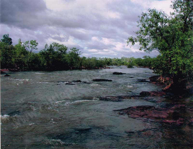 The Hodgson River.
The above photo is the Hodgson above in a relatively mellow mood. I don’t know the drop per km of this river but it is relatively shallow in some places like here but in places has waterfalls and descends down high escarpments. At times it is very broad like in this picture, about 150-200m in other places between escarpments it is very narrow of only 20-30mm.
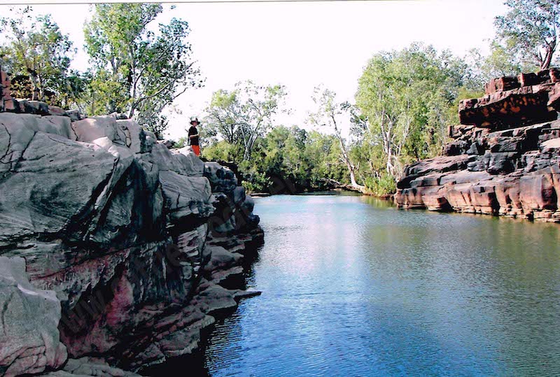 Permanent water hole.
This photo was taken late in the dry season. We think this is actually a spring which means it could be the standing watertable of the an intersecting point in a depression of permeable rock. It doesn’t mean this is the standing watertable level extending either side as that is determined by the confinement of the basalt layers and the location of permeable rock. Or it could be deep fractures of overlaying basalt from which the source of water has come from permeable layers that are below the basalt and is flowing to the surface through those fractures. This water hole is about 200km upstream from the actual Roper Bar and point of sea water contact, yet it does have saltwater crocodiles in it. We never swim in these large deep permanent water holes.
 The Hodgson when it is mellow during a dry season.
I’m standing on an escarpment looking down into the river of about 40m to the base. Mature gum trees are growing at the base level. The river itself is confined between this escarpment and another about 150-200m to the left. Escarpments like this dominate the trajectory of the river confining it to very distinct paths in the upper regions of its movement. Along its upper reaches the Hodgson is fed by many large creek systems, not as large as this but still very beautiful and rugged.
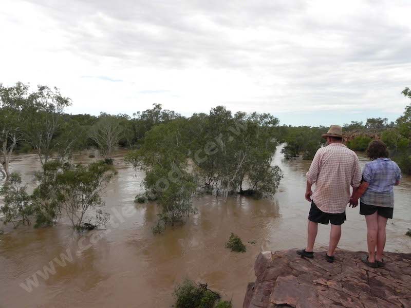 The Hodgson in the wet, the exact same position as the previous photo.
The river had fallen from it’s measured peak at the house and at the time of this photo in 2009 was about 10m (at the house), some of the debris can be seen in the trees still hung up around the trunks. Historically it’s highest recorded was 13.5m. This water as it stands we estimate is about 15-20m deep. Downstream escarpments form a bottleneck and cause the water to back up as it can’t escape to the floodplains further down river. Water is then backed up by a further blockage of the Hell’s Gate escarpment, as the water flow slows and spreads it deposits rich alluvial settlement in what is known as ‘downs’ areas. Magnificent open plains in amongst great rock formations, extensive pasture grasses grow in these regions. I’m not sure if the Hodgson actually cuts through the Hell’s Gate itself or joins the Roper before it makes a diversion of over 8km to get around the blockage it creates.
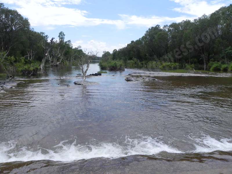 The Roper River 2011 at the Roper Bar crossing.
At the low level crossing in late dry season. This river is full of saltwater crocs, do not swim in it. A number of large aboriginal communities are located in the area as it was a heavily populated site before European arrival. Ludwig Leichhardt crossed the Roper in 1844 in one of his expeditions through the north of Australia. About 100 kilometres from this site is the Roper Gulf and the ocean.
Articles for this week will be:
1-Wild Wild Rivers – Explanation of site and formation of river systems (today).
2-Roller Coaster Seasons – Variances of the wet to the dry season in North Australia.
3-Strut your Stuff, The Animals – Native animals of the region.
4-Get tough or die, The Plants – Native plants of the region.
5-The Weird the wacky the wonderful – Oddities and incredible feats of nature.
6-The unwanted, often despised – The feral animals and weeds.
7-Monitoring sites – How producers can pro-actively record and assess their activities.